![]() Japantown
Atlas - Northern California - Stockton
Japantown
Atlas - Northern California - Stockton
Overview Map: Stockton Japanese American Businesses of 1940
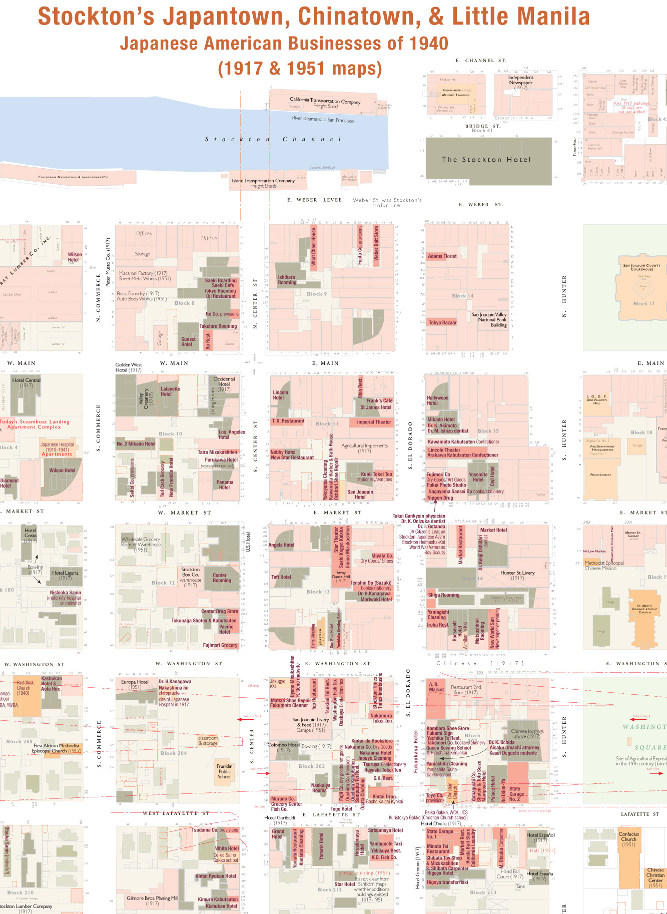
Data courtesy of Japanese American National Museum archives and the Saiki family.
Legend (will be restored; similar to the other detailed maps):
Residential: light green = dwellings,
medium green = apartments or flats; dark green
= lodgings or rooms
Commercial: lightest red
= industrial; medium red = stores and offices; dark
red = Japanese American businesses (named).
Community:
yellow = schools, social clubs, hospitals, etc.; dark
yellow = churches, temples, religious uses.
DRAFT text; a few preliminary observations.
 Stockton
was one of California's largest and most complex Japanese American communities.
It was both an urban center and farm service town for the San Joaquin Delta.
It was located in the Gold Rush-era waterfront district and existing Chinatown,
not far from the Santa Fe RR depot and the riverboats to San Francisco. Chinese,
Japanese, and Filipino immigrants settled here by 1940. (By the 1930s the same
area was also one of the largest Fillipino populations in the U.S.). Stockton
had a "color line" -- people of color were not permitted to live north
of Weber Street.
Stockton
was one of California's largest and most complex Japanese American communities.
It was both an urban center and farm service town for the San Joaquin Delta.
It was located in the Gold Rush-era waterfront district and existing Chinatown,
not far from the Santa Fe RR depot and the riverboats to San Francisco. Chinese,
Japanese, and Filipino immigrants settled here by 1940. (By the 1930s the same
area was also one of the largest Fillipino populations in the U.S.). Stockton
had a "color line" -- people of color were not permitted to live north
of Weber Street.
The 1940 directory indicates Japanese Americans were involved in a wide varietey of businesses. There were numerous hotels where agricultural laborers would stay in the winter. Community institutions included the Buddhist Church, a Christian church or two, a Tenrikyo church, and Nippon Hospital. The Buddhist Church Japanese school had a boarding house for students whose families lived on distant islands in the Delta. In 1940 the Buddhist Church had just built a new, larger sanctuary and separate hall/gymnasium. These served as hostels for Japanese Americans returning from the Internment Camps, from 1946 to 1951. Community life for this racially mixed corner of Stockton centered on Washington Square, which is just 1 block east of this map (between S. Hunter, Lafayette, and Washington Streets).
The Sanborn maps for Stockton are from 1917 and 1951; the older maps show many saloons near the waterfront on Eldorado; note the large number of handball courts and bowling in the yards of the non-Japanese hotels. Manufacturing, woodworking, and lumber yards mingled with residential use. Stockton's newer, more fashionable downtown began just at the upper right corner, anchored by the Hotel Stockton (today restored as affordable housing). The ornate, long-demolished San Joaquin County Courthouse is at the right of this map.
By 1951 the port and industrial uses had moved west, diluting some of the energy of the neighborhood. Gas stations and auto wrecking yards replace many houses. Stockton's Japanese American community would resettle closer to the Buddhist Church, but only for a short while. Stockton's Crosstown Freeway was routed through the heart of the neighborhood in 1961, and all but a handful of historic buildings were cleared for redevelopment. The lifting of the color line prompted many JAs to move north of Weber Street; other businesses relocated down to South Stockton along Highway 4. The Buddhist Church built a new temple in the northwest corner of Stockton (where it stands today).
The main surviving historic Japaneses American landmarks we know of are the Nippon Hospital (now apartments), the Nishomoto Transfer/Nippon Hotel building (for sale in 2007), and perhaps several buildings in the southeast-most block of this map, south of East Lafayette. The Catholic Church on E. Washington and the Chinese Confucius Church on E. Lafayette (both just east of this map) still survive. Little Manila Heritage Foundation is working to preserve the last three buildings of Manilatown even as the city of Stockton tears down its heritage and replaces it with gas stations and fast food restaurants to make a new, improved "gateway to Stockton."

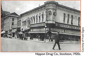
Above: Turn-of-the-century postcard (postmarked 1909) shows Stockton's waterfront in the formative years of Japantown, which begins on the right side of the picture. This view matches fairly closely with the 1917 Sanborn maps. Riverboats are moored in the Stockton Channel, with the Masonic Temple Auditorium (left) and San Joaquin County Courthouse (right) on the horizon. The Stockton Hotel has yet to be built. Stockton's Japantown extends south from the right side of the picture. At far right the ornate, brick Sperry Flour Co. office is one of the sole surviving historic waterfront buildings.
7/26/07, revised 3/14/08